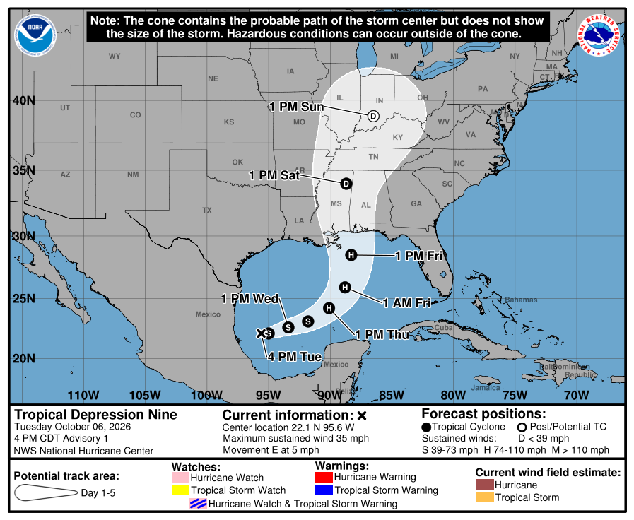
Subject: Tropical Depression Nine forms in the Gulf

AlertsUSA Logo - Allow Images

SMS Alert Text:


TD9 forms in the Gulf of America. Forecast to strengthen to hurricane Isaias with landfall along the northern Gulf Coast on Friday. Prepare now. More via email.


Supplemental Info:


Tropical Depression Nine is expected to become Tropical Storm Isaias and potentially the first hurricane of the 2026 Atlantic season, Gulf Coast communities must accelerate preparations now. Forecasts indicate possible landfall between southeastern Louisiana and the Florida Panhandle late Friday or early Saturday, bringing heavy rain, storm surge, gusty winds, and flash flooding that could extend far inland.


Residents should immediately review evacuation zones, secure outdoor items, stock water, nonperishable food, medications, and batteries, and charge devices. Officials urge checking local guidance before watches or warnings are issued, since rapid intensification remains possible and impacts could arrive by Friday. Early action reduces risk when time is short.


Formal hurricane Watches / Warnings expected tomorrow.


NHC Storm Page:

https://www.nhc.noaa.gov/refresh/graphics_at4+shtml/062038.shtml?cone#contents


Note the added resources below.


Traffic and Road Conditions


The potential for dangerous flooding with a coastal hurricane impact is high. As a result, increased situational awareness is advised if you or family members are heading out on the roads during such weather events.


National 511 System


On July 21, 2000, the FCC assigned 511 as a nationwide telephone number for intelligent transportation system (ITS) traveler information. Managed by the Federal Highway Admin. (FHWA), the system allows drivers to dial “511" on their phones and receive real-time traffic information. Depending on the time and system load, you will either hear recorded messages or speak directly with a human operator who can provide traffic information.


The websites below, covering states with normal potential for hurricane impact, provide interactive maps with real-time information on road conditions. All are accessible via mobile devices:


Service Notes:

This email message is a component of the AlertsUSA Homeland Security Threat and Incident Notification Service for mobile devices. You have paid for this service and are encouraged to archive these messages.


Service Issues? Let Us Know:

service@AlertsUSA.com


Discount Subscription (share w/ friends):

https://AlertsUSA.com/pages/ausab7


Threat Journal Weekly Newsletter:

https://ThreatJournal.com


Connect With Us On Social Media:

Twitter: https://twitter.com/AlertsUSA

Twitter: https://twitter.com/ThreatJournal

Facebook: https://www.facebook.com/AlertsUSA