Subject: NHC warns TS Idalia could become major hurricane

AlertsUSA Logo - Allow Images

SMS Alert Text:


NHC warns TS Idalia is strengthening, could be at major hurricane strength when it reaches FL. Interests in the eastern Gulf urged to prepare. More via email.


Supplemental Info:


From the 11:00PM Forecast Discussion:


"Idalia is sitting over very warm waters of about 30 degrees Celsius, and when it moves northward, it will be over the even deeper warm waters of the Loop Current in 24-36 hours. Although the trough over the Gulf could impart some shear over the system, this is likely to be offset by upper-level diffluence. Idalia has already strengthened more than anticipated, and the environment looks ripe for additional intensification, possibly rapid. The NHC intensity forecast has been increased and lies at the upper bound of the guidance. The new prediction now shows a 95-kt [110 MPH] hurricane over the eastern Gulf of Mexico at 48 hours, but it should be stressed that additional strengthening to major hurricane strength is becoming increasingly likely before Idalia reaches the Gulf coast of Florida."


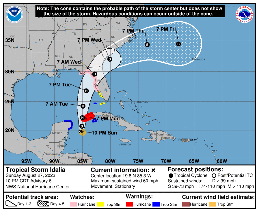
In the graphic below, remember that the cone shows an estimation of track forecast uncertainty. It does NOT represent the physical size of the storm NOR the extent of potential storm impact.


NHC Storm Page:

https://www.nhc.noaa.gov/index.shtml


TS Idalia Graphics

https://www.nhc.noaa.gov/graphics_at5.shtml?start#contents


TS Idalia Public Advisory:

https://www.nhc.noaa.gov/text/refresh/MIATCPAT5+shtml/280303.shtml


TS Idalia Forecast Discussion

https://www.nhc.noaa.gov/text/refresh/MIATCDAT5+shtml/280257.shtml?


Traffic and Road Conditions


The potential for dangerous flooding with a coastal hurricane impact is high. As a result, increased situational awareness is advised if you or family members are heading out on the roads during such weather events.


National 511 System


On July 21, 2000, the FCC assigned 511 as a nationwide telephone number for intelligent transportation system (ITS) traveler information. Managed by the Federal Highway Admin. (FHWA), the system allows drivers to dial “511" on their phones and receive real-time traffic information. Depending on the time and system load, you will either hear recorded messages or speak directly with a human operator who can provide traffic information.


The websites below, covering states with normal potential for hurricane impact, provide interactive maps with real-time information on road conditions. All are accessible via mobile devices:


Service Notes:

This email message is a component of the AlertsUSA Homeland Security Threat and Incident Notification Service for mobile devices. You have paid for this service and are encouraged to archive these messages.


Service Issues? Let Us Know:

service@AlertsUSA.com


Discount Subscription (share w/ friends):

https://AlertsUSA.com/pages/ausab7


Threat Journal Weekly Newsletter:

https://ThreatJournal.com 


Connect With Us On Social Media:

Twitter: https://twitter.com/AlertsUSA

Twitter: https://twitter.com/ThreatJournal

Facebook: https://www.facebook.com/AlertsUSAService Notes

AlertsUSA

Homeland Security Threat and Incident
Notification via Your Mobile Device